Cartography
The art and science of making and using maps.

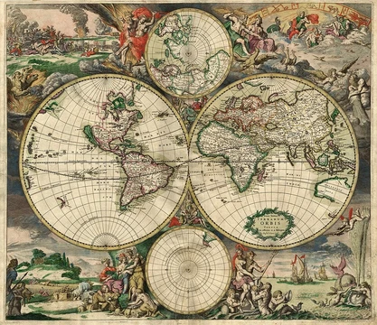
Cartography is the study and practice of making and using maps, combining science, aesthetics, and technique to model reality or imagined reality for effective spatial communication. Its fundamental objectives include setting the map's agenda, selecting traits, representing terrain on flat media, eliminating irrelevant characteristics, reducing complexity, and orchestrating map elements to convey a message. Modern cartography provides many theoretical and practical foundations for geographic information systems (GIS) and geographic information science (GISc).
- field
- Cartography
- known_for
- Study and practice of making and using maps; development of map projections, generalization, and design; foundation of GIS
Lore & Background
The earliest known map is debated, with a wall painting possibly depicting Çatalhöyük dated to the late 7th millennium BCE. Prehistoric alpine rock carvings from the 4th millennium BCE show geometric patterns interpreted as cultivated plots. Other ancient maps include the Minoan 'House of the Admiral' wall painting from c. The oldest surviving world maps are from 6th century BCE Babylonia (e.g., the Babylonian World Map). Ancient Greeks and Romans created maps from the 6th century BCE, and Ptolemy wrote Geographia in the 2nd century CE. Arab scholars translated Greek works into Arabic as early as the 8th century. In ancient China, geographical literature dates to the 5th century BCE, with the oldest extant maps from the State of Qin (4th century BCE). Early Indian cartography included depictions of the pole star and surrounding constellations.
Reader's Guide
Cartography's significance lies in its enduring role in human understanding and navigation of the world. From ancient wall paintings to medieval mappae mundi and al-Idrisi's Tabula Rogeriana (1154), maps have synthesized knowledge across cultures. Mercator also first used the word 'atlas' for a map collection. Renaissance maps served general description, navigation, and land surveying, and were displayed as art. By the late 1500s, about 10% of Venetian homes had maps. Cartography's legacy includes its foundational role in modern GIS and its continuous evolution in representing spatial information.
Did You Know?
- The oldest surviving world maps are from 6th century BCE Babylonia.
- The Tabula Peutingeriana is the only surviving example of a Roman itinerarium.
- Al-Idrisi's Tabula Rogeriana (1154) remained the most accurate world map for three centuries.
From Clay Tablets to Digital Screens
The story of cartography stretches back to approximately 2300 BCE, when the Akkadian Empire in what is now Iraq produced one of the earliest surviving maps, inscribed on a clay tablet. Centuries later, by the 5th century BCE, Greek mapmakers were sketching representations of their known world, which spanned the Mediterranean basin, much of Europe, North Africa, and the Middle East. The Age of Discovery elevated maps into indispensable instruments for mariners charting unknown coastlines. A significant conceptual shift arrived in the late 17th century with the emergence of thematic maps, which redirected focus from physical features like rivers and mountain ranges to specific data sets such as rainfall patterns or population density. The 20th century brought another transformation: the rapid growth of road networks and mass transit systems generated enormous demand for mass-produced maps aimed at everyday travelers. Then, in the mid-20th century, computer cartography and geographic information systems revolutionized the field, allowing vast quantities of geographic data to be stored, dynamically displayed, and analyzed in ways that paper simply could not support.
A Tool for Nearly Every Human Endeavor
Maps serve an astonishing breadth of purposes across society. At the most basic level, they enable route planning, helping individuals locate hospitals, gas stations, restaurants, or parks, and guiding vacationers to their chosen destinations. In commercial and recreational aviation and maritime contexts, specialized charts—called aeronautical charts and nautical charts respectively—guide air and water traffic. Scientists in geology, meteorology, seismology, and demographics rely on maps to organize and interpret spatial data. Governments depend on them for census operations, drawing electoral district boundaries, administering property taxation, dispatching police, and coordinating disaster relief. Local and regional authorities use maps for urban planning, designing roads, public transit, housing developments, and green spaces. Public and private utilities maintain their distribution networks for water, electricity, gas, telecommunications, and sewers with the help of maps. Emergency, fire, and police services turn to them for evacuation planning and responder dispatch. Military and security organizations employ maps for mission planning, surveillance, border management, logistics, and intelligence analysis. Even politicians and advertisers harness maps to promote agendas or persuade audiences.
The Delicate Craft of Mapmaking
Designing a map is far from a simple act of copying the landscape. Because the volume of available geographic data routinely exceeds what can be effectively rendered on a single sheet, cartographers must apply a generalization process, carefully deciding which features to include and which to omit. The level of detail a map can carry is heavily influenced by its scale, expressed as a ratio between a measured distance on the map and the corresponding real-world distance. Equally fundamental is the choice of map projection, since every projection inevitably introduces characteristic distortions that alter how the surface is represented. Geographic coordinates can be presented either as latitude and longitude or within a Cartesian XY grid system. Beyond the core geographic data—drawn from imagery, scanned paper maps, surveying measurements, geographic features, and terrain data—maps typically incorporate supplemental elements such as legends, scale bars, north arrows, and inset maps. The overarching goal is to produce a representation that is simultaneously informative, useful, and visually uncluttered, balancing richness of content against clarity of presentation.
A Word in Constant Redefinition
The English word "map" first appeared around 1527, likely derived from the Late Latin mappa, meaning a napkin or cloth, or possibly from the French mappemonde or Latin mappa mundi, both meaning "map of the world." The term's meaning has shifted dramatically over the centuries. In 1938, Erwin Raisz, writing in what is considered the first major English-language book on cartography, defined a map as a conventionalized picture of the Earth's pattern seen from above, with lettering added for identification. The late 20th century, with the rise of computers and interplanetary exploration, forced cartographers to broaden their definitions. Arthur H. Robinson offered a concise 1976 formulation: a graphic representation of the milieu. By 1987, John Brian Harley and David Woodward described maps as graphic representations facilitating spatial understanding of things, concepts, conditions, processes, or events in the human world. A 1992 definition further widened the scope to include maps as abstract models—visual, digital, or tactile tools for presenting geographical information. Outside cartography, "map" has long served as a metaphor, with dictionaries including figurative senses describing a conceptualization of the structure or layout of a field of study or ideology.
Frequently Asked Questions
Who is Cartography?
Cartography is the discipline that blends science, art, and technique to create and interpret maps, turning spatial reality—or imagined worlds—into flat, communicative representations. It sits at the intersection of geography, design, and mathematics.
What are Cartography's core abilities or role?
Its main tasks involve deciding what a map should communicate, choosing which features to highlight, projecting three-dimensional terrain onto two-dimensional surfaces, and stripping away unnecessary detail so the final product reads clearly. Think of it as the process of distilling the world down to its most meaningful spatial message.
How does Cartography's arc conclude in the 1-24 series?
By the end of the run, Cartography has evolved from a purely manual, artistic craft into the theoretical backbone underpinning modern geographic information systems and geographic information science. Its story doesn't so much end as transform into the digital infrastructure we now rely on for spatial data.
Why is Cartography considered foundational in the canon?
Every map projection, generalization rule, and design principle that later GIS platforms depend on traces back to cartographic thinking. Without its framework for reducing complexity and orchestrating visual elements, the broader field of spatial communication would lack its organizing logic.
What is Cartography's relationship to map projections?
Map projections are one of Cartography's signature tools—a specific technique for flattening the curved Earth onto a plane while managing inevitable distortions. They represent the practical application of Cartography's broader goal of making three-dimensional space legible on a flat page.
More in Map Projections & Cartography Foundations 1-24
Elsewhere in the Map Projections & Cartography Foundations universe
Spotted an error? Know more?
This is a living reference — every entry is fact-audited, and reader corrections feed straight into our audit queue. Suggest an edit · See this site's audit record