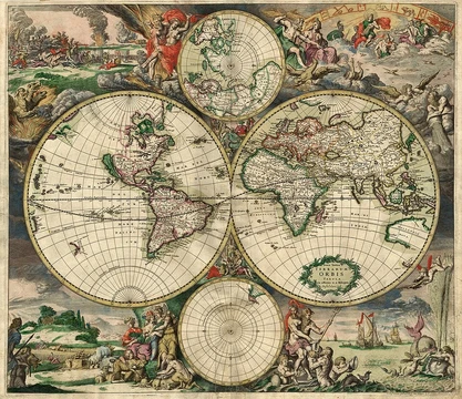
World map
A map of most or all of Earth's surface.

A world map is a map of most or all of the surface of Earth. Because of their scale, world maps must deal with the problem of projection, as rendering the three-dimensional Earth in two dimensions necessarily distorts geographic features, distances, and directions. These distortions reach extremes in a world map, and many techniques have been developed to present world maps that address diverse technical and aesthetic goals.
- definition
- Map of most or all of Earth's surface
- key_challenge
- Projection distortion
- early_limitation
- Less than half of Earth's coastlines known before European Renaissance
- mapping_milestone
- Most coastlines mapped by mid-1700s; continental interiors by twentieth century
- common_focus
- Political features or physical features
- notable_projection
- Mercator Projection, originally designed as a nautical chart
Lore & Background
World maps, because of their scale, must deal with the problem of projection. Maps rendered in two dimensions by necessity distort the display of the three-dimensional surface of the Earth. While this is true of any map, these distortions reach extremes in a world map. Many techniques have been developed to present world maps that address diverse technical and aesthetic goals. Charting a world map requires global knowledge of the Earth, its oceans, and its continents. From prehistory through the Middle Ages, creating an accurate world map would have been impossible because less than half of Earth's coastlines and only a small fraction of its continental interiors were known to any culture. With exploration that began during the European Renaissance, knowledge of the Earth's surface accumulated rapidly, such that most of the world's coastlines had been mapped, at least roughly, by the mid-1700s and the continental interiors by the twentieth century.
Reader's Guide
World maps serve as fundamental tools for understanding the Earth's surface, yet they are inherently limited by the need for projection. All world maps are based on one of several map projections, or methods of representing a globe on a plane, and all projections distort geographic features, distances, and directions in some way. The various map projections that have been developed provide different ways of balancing accuracy and the unavoidable distortion inherent in making world maps. Perhaps the best-known projection is the Mercator Projection, originally designed as a nautical chart. World maps generally focus either on political features, such as territorial boundaries and human settlement, or on physical features, such as mountains, soil type, or land use. Geological maps show not only the surface but characteristics of the underlying rock, fault lines, and subsurface structures. Choropleth maps use color hue and intensity to contrast differences between regions, such as demographic or economic statistics. Thematic maps portray geographical information about one or a few focused subjects, covering physical, social, political, cultural, economic, sociological, agricultural, or any other aspects. Early world maps cover depictions of the world from the Iron Age to the Age of Discovery and the emergence of modern geography during the early modern period, providing information about places known in past times as well as the philosophical and cultural basis of the map.
Did You Know?
- World maps must deal with the problem of projection because of their scale.
- Less than half of Earth's coastlines were known to any culture before the European Renaissance.
- Most of the world's coastlines had been mapped, at least roughly, by the mid-1700s.
- The Mercator Projection was originally designed as a nautical chart.
Frequently Asked Questions
What is a world map?
A world map is a cartographic representation that depicts most or all of Earth's surface. Because it flattens a three-dimensional globe onto a flat plane, it inevitably introduces some degree of distortion in shape, area, distance, or direction.
What is the biggest technical challenge in creating a world map?
The core difficulty is projection distortion—translating a spherical planet onto a two-dimensional surface will always warp geographic features, distances, and directions. Cartographers have developed numerous projection techniques to balance different types of distortion for various practical and aesthetic purposes.
Which projection is most commonly associated with world maps?
The Mercator Projection is the most widely recognized, though it was originally designed as a nautical chart for navigation rather than as a general-purpose world map. It preserves angles and directions, making it useful for seamanship, but it dramatically inflates the apparent size of regions near the poles.
How long did it take humanity to map most of Earth's coastlines?
Before the European Renaissance, fewer than half of the world's coastlines were known to cartographers. By the mid-1700s, most coastlines had been charted, though the interiors of continents were not fully mapped until the twentieth century.
What do world maps typically emphasize?
Most world maps focus on either political features such as national borders and capitals, or physical features like mountain ranges, rivers, and elevation. The choice between these two emphases shapes the map's overall purpose and intended audience.
More in Map Projections & Cartography Foundations 1-24
Elsewhere in the Map Projections & Cartography Foundations universe
Spotted an error? Know more?
This is a living reference — every entry is fact-audited, and reader corrections feed straight into our audit queue. Suggest an edit · See this site's audit record